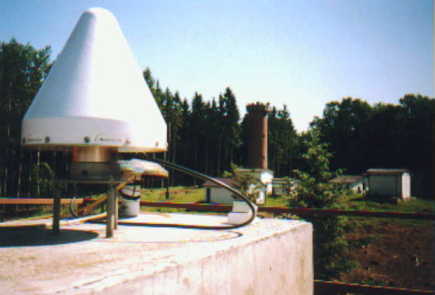
Description of GPS system
Since October 4, 2000 we measure with the Ashtech Z18 receiver, SN 113 and Ashtech Choke Ring Antenna, SN 3301 with protecting radome, IGS description ASH701946.3 SNOW. The following datasets are acquired:
- data from GPS NAVSTAR satellites every 30 seconds in daily files for IGS and EUREF (orbit determination of GPS NAVSTAR satellites, computation of coordinates of the GOPE station)
- data from GPS NAVSTAR satellites every 30 seconds in hourly files to monitor troposhere and for ultra-rapid orbit determination of GPS NAVSTAR satellites - data from GPS NAVSTAR a GLONASS satellites every 30 seconds in daily files to IGS (orbit determination of GLONASS satellites, to estimate differences between the WGS84 and PZ90 systems)
- data form GPS NAVSTAR a GLONASS satellites every 30 seconds in hourly files to IGS (data is sent to the data centers)
- data from GPS NAVSTAR satellites every 5 seconds in 5 minute files for DGPS postprocessing
- data from GPS NAVSTAR a GLONASS satellites every 1 seconds in 15 minute files (for processing of measurements from low-earth orbiting satellites)
Remark: files with measurements from GPS NAVSTAR satellites only are not sent - for the same purpose the files with measurements from both GPS NAVSTAR and GLONASS satellites are used.
S ite information forms from GPS system on GOPE station:
gope_20021014.log (current - IGS and IGLOS)
gope_20020503.log (new format for both IGS and IGLOS)
gope0205.log (IGS) gope0205.lgg (IGLOS)
gope0201.log (IGS) gope0201.lgg (IGLOS)
gope0107.log (IGS) gope0107.lgg (IGLOS)
gope0105.log (IGS) gope0105.lgg (IGLOS)
gope0010.log (IGS) gope0010.lgg (IGLOS)
gope0007.log (IGS)
gope9911.log (IGS) gope9911.lgg (IGEX)
gope9906.log (IGS)
gope9707.log (IGS)
gope9705.log (IGS)
gope9505.log (IGS)
The station is managed by operation center GOP (only in Czech).